Close Menu
California Flyer
    What's Hot

    Top air show performers commit to EAA AirVenture Oshkosh 2026

    January 21, 2026

    AOPA Announces Exclusive Aircraft Valuation Benefit for Members

    January 16, 2026

    National Association of Flight Instructors has named Brian Wynne as its Executive Director.

    January 12, 2026

    Please change to: Subscribe for Free

    Receive the latest news and events in California’s aviation community.
    Your email is safe with us.

    Facebook X (Twitter) Instagram
    California Flyer
    • Articles
    • About Us
    • Contact Us
    Facebook X (Twitter)
    California Flyer
    Home » Articles » Garmin Pilot 10.7 adds new graphical taxiway and apron NOTAMs
    News & New Products

    Garmin Pilot 10.7 adds new graphical taxiway and apron NOTAMs

    kentBy kentMay 9, 20222 Mins Read
    Share
    Facebook Twitter

    Garmin is excited to announce that the latest update (v10.7) for Garmin Pilot is available now. Among many other new features, the latest update now graphically displays taxiway and apron closures on the dynamic map – as well as SafeTaxi diagrams.

    10.7 update highlights:

    • Dynamic map enhancements: Our dynamic map has been optimized to change the visibility and size of navigation data, airspace boundary depictions and airport icons as the user zooms and pans around the map. When combined, these enhancements provide a clearer view of essential navigation data, airports, airspaces and more.
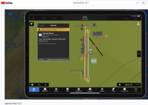
    • Graphical taxiway NOTAMs: For airports in the U.S., Garmin Pilot graphically displays taxiway and apron closures. When the NOTAM overlay is enabled, the taxiway or apron closed by the NOTAM is depicted with hashed lines and is color-coded — with alerts for taxiway and apron NOTAMs available throughout the application.
    • Annotate on screen: Take notes, draw taxiway routings, or highlight weather that may be a concern for your upcoming flight with the new, on-screen map annotation feature — which allows up to 3 pages of saved annotations at once.
    • Decoded NOTAM text: For quick and easy viewing, NOTAMs are now decoded into plain English whenever available — including on the airport page, radial menu NOTAM options and NOTAMs widget.
    • Expanded third-party support: Garmin Pilot now supports select Bad Elf GPS models and — when connected to Stratux — can also display ADS-B weather and traffic information as well as backup attitude and GPS position.

    New users can download a free 30-day trial, then enjoy a subscription for as low as $99.99 per year. Learn more about the 10.7 release here.

    –

    Watch the video here


    kent

    Related Posts

    Articles January 21, 2026

    Top air show performers commit to EAA AirVenture Oshkosh 2026

    Articles January 16, 2026

    AOPA Announces Exclusive Aircraft Valuation Benefit for Members

    Articles January 12, 2026

    National Association of Flight Instructors has named Brian Wynne as its Executive Director.

    Articles January 9, 2026

    CLEVELAND WHEEL & BRAKE SYSTEMS EXPANDS DISTRIBUTION NETWORK

    Articles January 7, 2026

    Articles December 18, 2025

    Climb Launches Adaptive TMS for Flight Training

    Comments are closed.

    Subscribe for Free

    Receive the latest news and events in California’s aviation community.
    Your email is safe with us.

    Facebook X (Twitter)
    • Home
    • Articles
    • About Us
    • Contact Us
    © 2026 Aviation Group
    website design and development by Dream Warrior Group

    Type above and press Enter to search. Press Esc to cancel.