


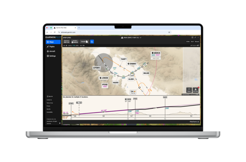
The dynamic, data-driven charts tailored to simplify terminal procedures can now be used for flight planning on a computer
Garmin today announced that SmartCharts, its dynamic aviation charting solution is now available for Garmin Pilot™ Web. SmartCharts provides pilots with a simplified and intuitive experience by producing clear and relevant data to depict a chart tailored for their specific flight operation. Now available on Garmin Pilot Web, Garmin’s powerful flight planning website that complements the Garmin Pilot mobile app, SmartCharts serves as the primary charting tool and allows pilots to view simplified terminal procedures, including instrument approach procedures (IAP), departure procedures (DP) and standard terminal arrival routes (STAR). Integrated into the flight planning flow, SmartCharts allows pilots to seamlessly evaluate the impacts of weather and NOTAMs on each procedure and provides a straightforward presentation of the resultant adjustments to minima or equipment required before ever leaving the ground. Additionally, SmartCharts airport diagrams are available in the Garmin Pilot mobile app on iOS devices and will come to Garmin Pilot Web in the future.
“SmartCharts have completely changed how pilots plan and brief instrument flights, and this capability now comes to Garmin Pilot Web. The decluttered terminal procedures allow pilots to focus on the most relevant and key information for their flight, ultimately helping to promote safety and situational awareness well in advance of stepping into the cockpit. Now, no matter how a pilot plans their flights, they can utilize our revolutionary SmartCharts.”
–Carl Wolf, Garmin Vice President Aviation Sales, Marketing, Programs & Support
Data-driven flight planning
SmartCharts uses digitized data from global sources to create a consistent, standardized and scalable charting solution. Garmin utilized that data to build the clearest possible picture of information needed to successfully fly charted procedures via a new charting user interface, which is now available in Garmin Pilot Web. This interface, coupled with the digital data, allows SmartCharts procedures to automatically adjust and scale as the pilot zooms and pans within the chart, similar to Garmin’s data-driven maps across its entire product line. This data also allows SmartCharts to highlight details and notes that could be easily overlooked and lost on traditional charts, or may only be available in a briefing from disparate sources. Integrated into the flight planning flow in Garmin Pilot Web, these highlights include adjustments to minima – such as minima height adjustments due to NOTAMs, alternate minimums, etc. – to be automatically calculated, providing a clear picture of impacts and allowing formation of a strategic plan for the upcoming flight.
The SmartCharts user interface is consistent across both Garmin Pilot Web and the mobile app, creating a seamless experience for pilots, regardless of which tool they choose to flight plan with. When using Garmin Pilot Web, the user has the ability to view charts in a split screen or a full screen, to take advantage of the additional screen real estate of the computer.
Simplified information
SmartCharts helps to optimize pilot workflow by providing only relevant data, important both in the cockpit and when flight planning. Users can make selections – such as aircraft type, arrival/departure/approach transition fix, runway, and more – to simplify the chart down to the information that they need to see, including information for their primary airport, or as they evaluate choosing a planned alternate. Starting with standard terminal arrival routes (STARs) and standard instrument departures (SIDs), the user selects their aircraft type, the route transition they are flying, and the runway of intended use. This reduces depicted information to only show the routing, fixes, and crossing restrictions pertinent to their expected procedure. Quick Access buttons also reveal pertinent procedure details like briefing information, communications frequencies, graphical missed approach icons, and more so pilots can easily find and decipher needed information as they build their preflight picture.
When viewing an approach procedure, approach minima are updated and presented to the pilot via easy selection buttons for aircraft category, approach type (e.g. ILS, LOC, LPV, LNAV, etc.) and other adjustments like local or other altimeter settings, inoperative airport lighting, flight director or HUD use, and more. Those selections then present only one minima number to reference, allowing for easy evaluation of go/no-go decisions or the need for further contingency planning.
The popular Approach Vertical Profile View is also available in SmartCharts on Garmin Pilot Web. Pilots can enhance the planning process by seeing terrain and obstacles below their approach path to the runway without ever leaving the ground. SmartCharts can be accessed via the Airports and Flights tabs, similar to Garmin Pilot mobile.
Garmin Pilot Web was launched in 2025 to ensure Garmin Pilot users could use the popular flight planning tool on any device, including their computer. Flights planned on Garmin Pilot Web sync to mobile devices for seamless planning and flying. For users that prefer to plan their flights on a computer, adding SmartCharts to Garmin Pilot Web gives them the most consistent experience so they can plan with SmartCharts on their computer and fly with SmartCharts on their iOS mobile device.
SmartCharts are available on Garmin Pilot Web and the Garmin Pilot mobile app with a Premium subscription in the United States and the Bahamas at launch. For pilots looking to try out SmartCharts and Garmin Pilot for the first time, they can take advantage of the 15 for 12 promotion, available at Garmin.com/AviationPromotions.
To learn more, including how to use SmartCharts from chock-to-chock during operation, visit Garmin.com/SmartCharts.
Garmin products and services have revolutionized flight and become essential to the lives of pilots and aircraft owners and operators around the world. A leading provider of solutions to general aviation, business aviation, rotorcraft, advanced air mobility, government and defense, and commercial air carrier customers, Garmin believes every day is an opportunity to innovate. Recipient of the prestigious Robert J. Collier Trophy for Garmin Autoland, Garmin developed the world’s first certified autonomous system that activates during an emergency to control and land an aircraft without human intervention. Visit the Garmin Newsroom, email our media team, connect with @garminaviation on social, or follow our blog.
